Showing posts with label Coorg. Show all posts

Friday, April 30, 2010

The Kaveri Nisargadhama (Coorg Exclusive - Part 3)


The experience on day 1, when we thorougly enjoyed the twisty trail (read the post here) and later the beautiful Raja seat and children's park (Read the Madikeri post here), were enough for us to set the expectations of the day sky high. The real cool climate ensured a very good sleep at night and we could not get up at 6.00am as planned. It was almost eight when everyone was ready for the days sojourn.

But first things first, we had breakfast from Hotel Hilltown and found out that the food there is simply superb. On one side of the restaurant there was a big board with photos of all the picnic spots around Coorg. The breakfast proved an ideal time for us to discuss on the plans for the day.

The options were

1. Iruppu falls - 60 kms away from Madikeri - towards the Kutta route. It was on the way which we came. So decided to explore it on our way back, if time permits. Had we known this earlier, we would have checked it on our way to Madikeri.

2. Kaveri Nisargadhama - An island, 30 kms from Madikeri and the pictures were quite tempting too. Location is in the Mysore route.

3. Golden Temple, at Kushal nagar, where there are budhist monastries and the picture of the temple was awesome too. This place is after Kaveri Nisargadhama in the Mysore route.

4. Dubare forest - Which is also in the Mysore route 25kms from Madikeri.

5. Abbey falls - 9 km from Madikeri, which we didn't check out yesterday.

So we charted out a plan as follows.

First visit, Kaveri Nisargadhama then Golden temple and Dubarey forest, return to Madikeri by 3 pm, check out from hotel, do some shopping, then have a quick visit to Abbey falls, and start return journey by 5pm.

All plans set, we started our journey, passed Madikeri Town and took the route to Mysore. A little after 1km saw a junction with two roads, one to the right and one straight. There was a sign board on the right road which mentioned many places and distances to them. But the straight had just one board pointing to Mysore and the road was big too. So we had no doubt on which road to take.

The road was wide, but some construction was happening on one side, the ambience exquisite.


We moved another 2kms and suddenly saw a road closed sign. Do we have to go back?. A police man was diverting traffic to a nearby side road and we confirmed with him whether could reach our destination - Kaveri Nisargadhama, by taking this route, to which he replied in the positive.

The roads eventhough narrow, was really beautiful with long trees on both sides.


There was no traffic on these roads, weather was cool and we were gliding along.


We lost track of the distance travelled, since all of us were busy in singing songs all the while enjoying the winding roads, but no towns were in sight even now.


We had travelled a distance of 30kms from Madikeri, when we reached this open place.


The distance to our destination being 30km we were expecting to reach there in short time.

I spotted a beautiful bridge some distance away and instantly ensured that the light reflected from it fell on my CCD sensors. 


That could be the Kaveri Nisargadhama, our intended destination. Moved further ahead and reached the bridge which we saw from distance.It was not Kaveri Nisargadhama, but we to stop there coz I don't think any one who loves the nature can resist stopping on top of this bridge. 


If the view on one side of the bridge was superb
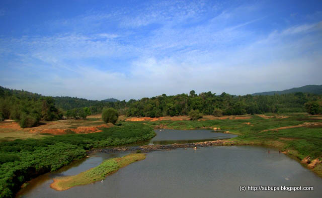

The view on the other side seemed to be competing with the opposite one.


The river, the sprawling lawns around, the trees in the background and the Mountains far away all formed the right mix of ingredients for that perfect ambience and we ended up spending about half an hour on this bridge and went on a shooting spree, occassionally modelling in front of this landscape too.


We were even tempted to go down the bridge towards those sprawling lawns, but then our plans may not work out. Also we were aiming for a return trip today evening. It is now 11am and we have still not reached our first destination. So we decided to bid adieu to this beautiful landscape.


Roads suddenly became narrow and there was no sign of our Kaveri Nisargadhama even after 40km from our starting point a good 10km more than what we had expected. We were nearing a small junction.
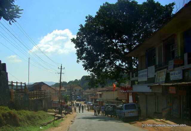

On enquiry we found that we have to travel another 10km to reach our destination. Even though this amused us coz we have to travel almost 20km more than what the sign board mentioned at Madikeri. We might have chosen the wrong route, but then who cares, we were treated by brilliant landscape all the way.

Just after this junction, the roads suddenly became very wide and seems to be recently laid.


Naturally the speed of the vehicle increased as the vehicle seemed to grip really well in this road even at turns. The sign boards were pointing to Mysore, so it seemed to be Mysore highway and the distance was about 80kms. 


All of us were truly absorbed in the drive that we missed our destination on the way and proceeded further ahead, until on enquiry we found that we are 4km ahead. So we turned back, drove slowly and found the sign board pointing to Kaveri Nisargadhama. The place seemed to be a highway side restaurant and nothing more. We entered the parking lot, took the entry ticket and enquired about the activities here to the person at the ticket counter who elaborated the facilities clearly.
Time was 11.30 am when we reached here.

The entry to Kaveri Nisargadhama was very inviting.


There was a hanging bridge at the entrance itself which took us to the island..


The walk through this bridge was quite interesting, kids were enjoying too as it was shaking as we move ahead.
We could get a good view of the Kaveri river with a thick cover of lush greenery on both sides.


There was boating facility in the Kaveri river underneath.


When we looked closely down we could see lot of fishes moving ahead in formation. They seem to be quite big fishes coz we could see them even from this much height and the patterns which they formed was interesting too.


We could spot a small deity on the other side of the bridge which was really shining because of its gold plating and the green background, thanks to the lawns.


As we crossed the bridge we got a closer view of the diety.


Once in this place, it seemed to be quite huge, and there were many side roads, one leading to the boating point, one to a viewing deck made of wood, one to a river and one to a deer park.

We opted to do away with the boating and went straight to the viewing deck. The viewing deck made of wood looked a bit dangerous. The kids and lady folks did not venture getting into the deck. Once on top of it, one gets a feeling of flying on top of the river flowing below.


Soon we found ourselves walking amidst the bamboo trees towards the deer park.


On our way we spend sometime near a kids park, to feed the hungry stomachs with some snacks as it was almost lunch time in our normal routines. There were plenty of monkey's around to give us company. There some really scary monkeys too who were bold enough to snatch the eatables, especially from kids.


We continued our walk towards the deer park. Suddenly we saw some movement at a distance. A huge elephant appeared from behind the bamboo trees


There were 6 people on top of elephant. They were enjoying an elephant ride through these beautiful surroundings. We saw the raised platform from where the people get on top of the elephant. 


We did not opt for the elephant ride, rather sat and enjoyed the majestic animal from a distance.


The deer park was also nearby, kids enjoyed watching the sedate but beautiful animals roaming around.


This island seems to be a very sprawling one and the really cool climate and the breeze flowing across made walking around a very easy business without getting exhausted and it was a real welcome change from the humid summer back in my home state.

We were soon walking towards the river point. This island is surrounded by river Kaveri and some points the river is very shallow where visitors are allowed to enter.

On our way saw a bamboo house on top of a bamboo groove. It had a fairly good height. But that was not going to deter me or my wife from climbing up. We soon found ourselves in top of the woods and had a nice time enjoying a different perspective of the surroundings.


We also decided to have a photo shoot in various poses over this tree house. The climb up and down through the shaking wooden ladder was a little fearful, but we tried our level best to hide the fear factor while posing


A short walk from this bamboo house and we reached the Kaveri river smoothly flowing across grazing the rocks and tempting all of us to lay our feet on it.


All of us stepped into the river. The bottom profile was rocky and hence sligtly slippery, but there was no depth at all. Moved to the centre point and the view was amazing. Sat on one of the rocks in the middle and this is what you get to see in your front.


The two trees bending over seemed to enhance the total ambience.

The view towards the other side was equally enterprising.


Undoubtedly this is the most beautiful location of the whole island.
We sat there for almost an hour enjoying the water gushing through our feets. Kids also enjoyed this place too much as they really like to play in water and the narrow depth ensured that we could allow them to play fearlessly.


It was almost 2 pm when we decided to move on from the midst of Kaveri river, for this place had some kind of attraction which was not letting us to go. Neverthless we made our walk back through the bamboo groves and big teak trees.


During our walk back our main discussion centered around the slippage in our planned schedule. We had planned to be back at our hotel after visiting this place and golden temple by 2pm. It is already 2pm and we are still at Kaveri Nisarghadama enjoying the ice creams in the cool atmosphere after having a nice walk in beautiful surroundings for the last 3 hours. Meanwhile some one suggested on extending the stay to tomorrow, since we came to relax and not to rush things around and nobody had any objections to that since this place has created an impact on us and we were rather reluctant to go.

Called up Hotel hilltown and asked whether we can stay till tomorrow afternoon, which they readily agreed. So that means we get one more day at Coorg and were feeling very happy, since we need not hurry up things. We did not even have our lunch till this time, but the intake of snacks and the catchy environment ensured that we forgot our hunger.

Slowly we started our journey to the next location - The Golden Temple at Kushal Nagar (To be continued in Part 4)


Quick Facts

Name of Place:  
Kaveri Nisargadhama

Location:
80 kms from Mysore in the Mysore - Madikeri Highway.
30 kms from Madikeri, in the Mysore route

Travel plan:
Check out this place on your way to Madikeri, if you are coming from Bangalore. this is just after Kushal Nagar. Easy to miss the board. Hence keep an eye on the left side after Kushal Nagar.

Time needed for a visit:
Ideally you can spend one full day here. A minimum of 3 hours is needed.

Hotel:
Food is available inside the island and also there is restaurant near the parking lot

Stay;
There is a govt owned guest house in the island. Else opt for a stay in Madikeri - the hill station in Coorg.


The story so far

Part 1 - A tale of a twisty trail ( The road trip through beautiful Wayanad to Madikeri)

Part 2 - Explore Madikeri ( The raja seat and children's park at Madikeri)

Sunday, April 25, 2010

Coorg Exclusive - Tale of a twisty trail


Two weeks leave from regular routine. Reason being a marriage at home. When we embarked our journey to our native place for this marriage, never did we think that coordinating a marriage will be this hectic and tiresome, than what we daily encounter at office.

It is true that marriage is a time when there is joy in the whole family, a time for reunion with all the relatives, neatly dressed people around, beautiful colors around and a happy bunch of crowd around. But along with it we also got a lesson or two on managing (or rather mismanaging) crowds which contained people of all kinds. Among them were some who supported whole heartedly, some people who acted as supporting but who did nothing, some who were there just to air their opinions, some who like to just give orders without doing anything, some who just kept on complaining about all the arrangements and the type goes on. Neverthless we had some real fun and our family worked as a close knit unit to ensure to the maximum extent possible the comfort of our guests, all of which resulted in a grant marriage party.

Once marriage was over and all the relatives left, we suddenly felt a void after a high of about 4 to 5 days. Wife and myself had an extended leave and kids also were feeling the loneliness after the celebrations. Thought of a best way out of this lull.

I cannot think of anything else but going for an outing together, a travel to a cool destination as mercury was rising in this part of country at an alarming rate. Everyone readily agreed, including the just married couples who decided to come along with us rather than going for a honeymoon trip together to enjoy the initial phases of togetherness when everything in the world seems to be more beautiful than ever. Since both of them work at another state, chances for them meeting up with all of us is only very rare and so they decided to have a trip together. Since we were at Calicut the nearest hill station we can think of was Waynad. But we have been there umpteen times, hence everyone voted against it. A host of other names also propped up, but after much brainstorming everyone agreed to was Coorg. I was assigned with the duty of making all the arrangements and everyone was excited.

We were really happy thinking of the impending, exciting trip next day, but murphy's law chirps in and I got very high fever and was finding it really difficult to get up even from bed. Everyone in the family advised against a trip and I could not check internet for the route or book any hotel. The day went alone and I was really upset that just because of me, we all going to lose pretty good time together which is not a regular event. The day passed by and 8 pm in the night, I somehow managed to browse and rang up some of the numbers which propped up after a google search. The best response I got was from Hotel Hilltown of Madikeri. Booked three rooms for one night and I thought that if at all we won't be able to go we will cancel the booking. The guy at the other end told about the route too. When I announced to everyone that I am feeling good and booked a room for tomorrow's journey I could see the radiance in every ones face. I firmly believed that by tomorrow morning I will be fine.

The plan was to start early, cover the distance of 250kms and reach Coorg by 12pm, be at Coorg till next day 12pm, check out from Hotel and return back by night on second day.

Packed our bags and went for sleep. Normally during journey days my subconscious mind don't allow me to sleep after the intended wake up time. But this time it was violated and we all got up only at 6 am in the morning and by the time we all got ready it was 8.30am and the trip was started only at 9.00am.

The trip party consisted of 6 adults and 2 kids. Calicut is a city which gets up pretty late, hence traffic was less eventhough it was 9am and we were in the Wayanad route pretty quickly.

The route plan was
Kozhikkode (Calicut) - Wayanad - Mananthavady - Virajpet - Madikeri.


As soon as we entered the Wayanad route the twisties started and the camera was nicely warmed up for a shooting spree ahead. The roads were butter smooth, the surroundings were lush green and the everyone was charged up. A shot taken from the speeding vehicle.


Soon we reached Adivaram, the last of the towns before the twisty roads upwards to Wayanad starts. A little ahead on our way saw this beautiful hanging bridge. Normally we sees such bridges in the picnic spot, built as a fancy structure to attract tourists. Here it was by no means a fancy object but a practical one for the use of the people around here. It is beautifully constructed.


The boards signing entry to the Wayanad high range routes was soon seen. Everything set for a twisty trail. The altitude was slowly increasing and our field of vision was increasing as we progress. There was tinge of coolness in the air too. I was wondering how to take a snap of the beautiful road with the great surrounding, but the shots which I took on the way was not giving a clear picture and I was feeling bad at my work.


A total of 9 hair pin bends to negotiate, the really wide and smooth roads, the extra width and the extra concrete padding on those twisties ensuring a smooth cornering and the passengers did not feel any strain at all. We finished all the hairpin bends in quick time and I was worried that I could not take any snap enroute. Saw a viewpoint and stopped instantly. Just have a look at where we stopped


Crossed the road to have a look downwards. We were really at a very high altitude and has got a very wide range of area in our scope of vision. On a closer look found the road which we took, zoomed the camera to its maximum extent possible and snapped the route. Voila three hairpins on a single shot.


The design effort and the implementation complexity of the roads through these mountains is well evident in the above pic. Also see that whenever the hairpin is on the edge of a cliff, the roads are concreted. Naturally this was my favourite pic of the day and compensated for the lack of any shots while I was on those twisties.

Spend some time here, transferring some of the eatables which we had from the containers to the container in the middle section of our body.

We started again, roads continued to be good, but it were not as twisty as earlier. Some distance ahead we saw a board pointing Pookot Lake. 


We all had been to this lake sometime back, hence did not venture into this spot, where boating facilities are available and the view of the magnificient mountains from the lake is quite awesome.

Eventhough we travelling on plain roads there were some huge hills on our sides.
A thick black object was seen in the sky and we all were wondering what it is. On a closer look found out that it was a mountain with its complete area except the peak covered with clouds.


Next town in sight was Kalpetta. A little after Kalpetta the road splits into two, one which goes towards Sulthan Bathery and the other one towards Mananthavady. We had to take the Mananthavady route. From here on roads became little bad.

Found a majestic big guy on the road. No it was not a wild tusker. It was a tamed one left on the road side for having some food.


Sighting an elephant is always a curious thing eventhough we have sighted it many times. Really salute the brilliance of mankind to bring such a powerful animal under his custody.

Next thing to capture our interest was this overhead canal (I think it is a canal).


Once underneath this canal, it seems to start from infinity and extend to infinity. But I could not manage to take a shot to show its tremendous length.

It was almost 11.30 am when we reached Mananthavady. Decided to stop at a hotel to recharge and refresh ourselves. We did not have our lunch, but had a feast of Parottas which is the speciality of this place. Even more interesting is to watch how these parottas are made, the way in which the person throws the dough in the form of sheet.

Our mile muching restarted a little after 12 pm and the route we have to take was towards the famous Thirunelli temple, due to which finding directions was not a pain at all.

Surprisingly roads turned to be too good and seems to be recently tarred and we got an impression of travelling through thick dense forest with no one else other than us around. 


The terrain began to look increasingly beautiful as we progressed further, with the recently laid tarmac providing sharp contrast to the greenery around. 


The roads were twisty and it was becoming a great experience to negotiate these twists and I was driving in the most leisurely manner, while the occupants inside was busy singing popular numbers of Malayalam, Hindi and Tamil films. The mood was upbeat and suddenly the visual treat was even more enhanced when we were engulfed between long and beautiful teak trees.


This stretch of road starting from Mananthavady was not expected to be this good and we all enjoyed being here. The sign board showing the deviation to Thirunelli temple was in sight and we had to take the Nagarhole route.


The border of Karnataka state was very near. The next major junction being Kutta, we confirmed with the localites on whether we are on the right direction.

Roads and the ambience around continued to amaze as the teak trees gave way to beautiful bamboo trees and there were lot of monkeys on sight too. We stopped when we saw this big family on road.


It is really interesting to watch the gestures and actions of monkeys and how much they resemble us. The way their babies are being carried along, the way they are fed, the way they care for each other, we spend some time there without getting out of the vehicle, but silently watching them.

We were happy to see more good roads as we had earlier thought that there were some real bad roads on way to Coorg, which was not the case here.


But all good things have to end, and it was the same in the case of roads too. There was a quick change and some really big potholes was upfront.


The thank you come again board of Kerala state was soon on site amidst the undulations in the road.


The road was so uneven that we were literally moving at a snails pace.
We saw many white thingys flying across which was indeed cotton flying of from tree cottons (http://en.wikipedia.org/wiki/Gossypium_arboreum) which was aplenty. Most of the passengers decided to step out on road and walk amidst these rich and varied flora and fauna as I negotiate through these potholes.


Watch the white cotton on the plants ahead in the above pic. The density of raw cotton fibres increase and it was a real treat to watch them sprawn across the road.


The newly wed couple also was having a nice stroll through these jungle roads.


The bad roads continued, the stroll continued and vehicle also accompanied at snails place giving the feeling of a roller coaster ride.

I had to stop after 1 km just to take a breather.


Eventhough the roads were bad or to be more precise worst, what we get to see around was very beautiful and the snails pace means we could enjoy the ambience for more time rather than just zoom past.


Soon the minimal worst roads turned to zero roads and it was quite dusty too. To add to the woes one side of the path was dug up too. I even wondered whether we will be able to proceed ahead as we see no vehicles on road too. Neverthless I stopped to pick up the fellows who was finding it pretty difficult to even walk through this road amidst the dust.


Soon a bus whizzed past and this is what I could see from its back.


It was a houdini trick, the bus disappeared in the dust. Thanks to the bus, we were sure that we were on a motorable road. Everyone got inside the vehicle and we continued our roller coaster ride. This bad road does not seem to end. We had still not reached "Kutta". That means we have not travelled even 2 Km after the border sign which we saw sometime back.

A little ahead I saw a stream on the left side and the vehicle came to a halt again for a snap of the beautiful landscape.


Again the stroll continued, and suddenly I heard a scream from inside the vehicle, almost everyone was screaming and you know why, they spotted the end of the bad road and start of the good road ahead. That was an awesome site after the bumpy ride through no roads.


Kutta junction was in sight and there was no confusion in route since there is no deviation from here. The next major junction is Virajpet. According to what the hotel guy told yesterday our destination Madikeri is after Virajpet. So we expected that Madikeri will be nearby. Also a little ahead of Kutta we began sighting boards of Coorg Homestay. The roads were neat and clean and there were no undulations, but it was quite narrow.


The roads were so narrow that, we had to move out of the road whenever vehicle comes in opposite direction. We travelled for around 30kms in the same kind of road, but there was no sign of Virajpet. Another local junction was approaching and we could sight some sprawling mountains in the backdrop. The clouds also were creating different patterns.


Enquired with a localite on whether we are on right direction. The guy whom we approached was very cordial and he even told the distances to Virajpet and Madikeri. We were surprised to hear that Virajpet was a good 30km more away and madikeri was around 80 km more. It was already 2pm and our plans for having at lunch at Madikeri seems toppled. The travel was not boring at all since all of us were really enjoying the surroundings and interesting discussions inside the vehicle.

Another round of offroading session ensued soon as the roads suddenly become horrible again. This time people inside opted not to get out and have a walk, since it was really dusty.


Once this set of bad roads were over there was a wide open stretch, with beautiful landscape around.


The open kind of landscape soon changed to hilly stretch with lot of coffee plantations around. All through this route there were boards of homestay underwhich the name of place were written as Coorg, which gaves a false impression that we are already at Coorg.
The coffee plantations with the flowers was a treat to watch.


The wide open lands soon gave way to some shops and houses around signifying the arrival of some town. A little ahead a sign board on top of the petrol pump let us know that we have approached Virajpet.


Once we reached the junction there were some three of four cross roads, we had to take the left turn and a little further ahead right turn and reach the Madikeri route. All these turnings were made after enquiry with the local people who surprisingly spoke in our mother tongue Malayalam, rather than Kannada, eventhough these places were in Karnataka.

Virajpet disappeared from the rear view mirror and the terrain again looked similar to what we saw just before Virajpet, with coffee plantations on hilly areas, paddy fields on the plains. Soon we thought of having lunch, making use of whatever eatables available in the vehicle. I was soon on the lookout for a nice open area where we can have our lunch. After travelling aroun 20kms from Virajpet I found this open area on the left side.


Everybody agreed to make this place our lunch destination and soon the vehicle was parked in the middle of the wide open space. Everyone was really hungry and the set for lunch was established pretty quickly and the process of gulping in food was executed with great vigour, while me and my wife's sister's elder son had a work out of our bodies by jumping around playing the flying disc.

After the nice work out we could easily finish all the food at great speed. The landscape was quite attractive and the clouds began to create different patterns making it even more beautiful.

Right throughout our stay here we were given good company by this little puppy.


This puppy's mother was also around and even though we were having food they did not approach us creating trouble and sat obediently at distance watching all of us eat. Their patience was duly rewarded by us and they too had a little meal.

Again the wheels started rolling, but the heavy meal and tiredness of travel made all the occupants doze off in pretty quick time. The roads were beautiful as expected.


Since everyone was sleeping, the speed of the vehicle also increased and I decided to stop my photo shooting spree, since that will increase our travel time as I used to stop the vehicle to take snaps of the surroundings. There was another stretch of high ranges and trail become even more twisty. I ensured that the vehicle does not sway much just to ensure that the sleep of all the passengers is not affected. The altitude was increasing steadily and I could feel the pressure difference in my ear.

It was about 4.30pm, when I finally this junction which was Madikeri, our destination.


It was not crowded at all. A little more ahead saw some Buddhist monks, a trademark of Coorg as there are many monasteries around.


Called up the hotel Hilltown, where we had made the booking and the guy directed us the take the right turn in the second round when coming from the southward direction. Finally by about 4.45 we were at the hotel's parking lot downloading the luggage.

It was a long journey, not in terms of distance as we travelled only about 250kms, but our relaxed drive, multiple photo stops, many food breaks, bad roads and the twisty roads ensured that we were on the road right from 9am till about 5pm in the evening.

But twisty trail was really interesting and we enjoyed every bit of it.

Click here to read Part 2 - Exploring Madikeri !!!

Some Quick Facts

Where is Coorg?

Coorg is a hill town at the Kerala Karnataka border.

How to reach from Kerala?
Route 1
Kozhikkode - Wayanad - Mananthavadi - Kutta - Virajpet - Madikeri
Bad roads between Mananthavadi and Kutta. Good roads else where. Also can visit picnic spots in Wayanad on the way. Plan for an early morning start from Kozhikkode, enjoy all the locations of Wayanad - Pookkote lake, Edakkal caves, Thirunelli temple etc, ensure to pass Kutta before sun sets and reach Madikeri by night.

Route 2.
Kozhikkode - Kannur - Kathirur - Iritty - Kutta - Virajpet - Madikeri
Really bad roads between Kathirur and Kutta. This will take more time than the Wayanad route. But for those coming from Kannur or places further north of Kannur this is the easiest route.

LinkWithin

Related Posts Plugin for WordPress, Blogger...